Grey Reef
Fishable
Flow500 CFS
Trendstable
Clarityrain-stained through much of the system; cleanest water is up near the dam
Temp62-65°F
Sparkle Wing RS2 #18Poxyback PMD #18Sparkle Worm Red #10Pine Squirrel Leech (rust/orange) #10
| What | When | Key Numbers |
|---|---|---|
| Winter base flow | Roughly October through February | ~500 CFS; best wading of the year |
| Flushing flow | Ten days in March | 500 CFS to 4,000 CFS daily, peak 3-7am |
| Irrigation season | Roughly May through August | 2,000-3,000 CFS typical; float water |
| Trophy brown trout | Mid-October through November | Streamers and eggs; flows back near 500 |
| Trout density | Wyoming Game and Fish, 2026 | Over 3,500 trout per mile |
| Creel limit (dam to Hwy 220 bridge) | Year-round | 1 trout per day, all under 20" released |
| Guided float | Book by February for spring | $550 half day / $675 full day per boat |
| Fly shop | Platte River Fly Shop | 7400 State Hwy 220, Casper |
Grey Reef is the tailwater below Gray Reef Dam on the North Platte River, about 30 miles southwest of Casper off Wyoming Highway 220. It produces rainbow trout in numbers and sizes that most Western rivers cannot match, and it does it year-round, in country that looks like it should not hold trout at all.
Before anything else, understand this: Grey Reef is a dam-schedule fishery. The river runs on a release calendar set by the Bureau of Reclamation in coordination with Wyoming Game and Fish, and that calendar drives the fishing more than any hatch does. Anglers who know where the river is on that calendar show up at the right time with the right rig. Anglers who do not show up in July expecting to wade, or in March expecting a normal river, and they leave confused.
A note on spelling, because it trips people up in search. The dam and the reservoir are officially Gray Reef, which is what Reclamation and the Wyoming fishing regulations use. Anglers, fly shops, and guides write Grey Reef. Same water either way.
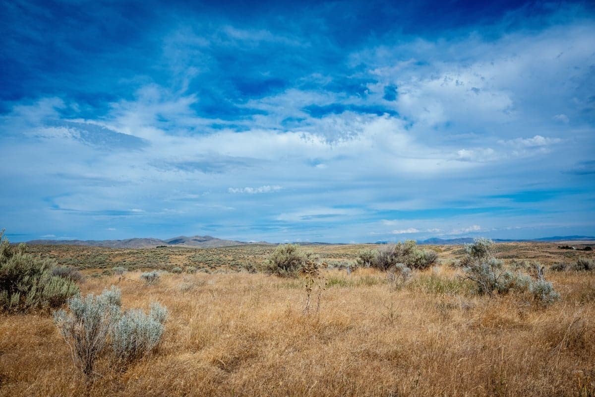
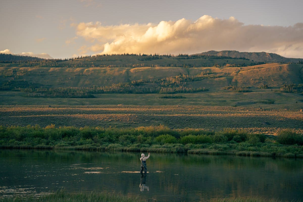
Sagebrush plain. Grey Reef sits in country like this, where very little stands between you and the weather.
Gray Reef Reservoir is small, about 182 acres, and it sits just below Alcova Reservoir. Its job is re-regulation: it catches the swinging hydropower releases from Alcova and smooths them into a steady flow downstream. Reclamation notes the reservoir surface can go from nearly full to nearly empty in a single day while doing it. That is the mechanism behind the whole fishery. The trout below the dam get the smoothed-out version.
Here is the year, in order.
Once irrigation season ends, releases drop back to around 500 CFS and hold there. This is the best wading of the year at the public access areas, and the boat traffic disappears. Fish concentrate into the deeper runs where you can find them, midges come off daily, and the productive window is short: roughly 11am to 3pm, when water temperatures nudge up. Midge larvae and pupae, small leeches, and scuds through the slower water. The access roads are usually driveable, but this is open country and the air temperature is a poor guide to how the day will actually feel.
People sometimes place this in autumn. It is a spring event. Every March since 1995, at Wyoming Game and Fish's request, Reclamation runs a ten-day cycle of fluctuating releases below the dam. Flows climb from about 500 CFS to 4,000 CFS, peak between 3am and 7am, and are back down to 500 CFS by 10am. Then it repeats the next day.
The point is to scour winter's accumulated fine sediment out of the spawning gravels. Wyoming Game and Fish reports that before the program started, trout numbers here often fell below 400 per mile and the river needed hundreds of thousands of stocked fingerlings a year. The population now averages over 3,500 per mile with essentially no stocking of that reach. Reclamation manages the cycle without losing power generation, and the water released from Alcova gets restored downstream in Glendo Reservoir.
For an angler, the flush means two things. First, the river is off-color and unsettled during it and for a few days after, and morning flows are genuinely dangerous to wade. Water that is comfortable at 500 CFS is not comfortable at 4,000 CFS. Second, the fishing right after the flush clears is often excellent, because the flush dislodges worms, scuds, and leeches into the drift.
Dates move. In 2026 the flush ran March 5 through 14, about two weeks earlier than usual because Reclamation had maintenance scheduled at the dam. In other years it has started as late as March 20. Do not book around a guessed date. Check with a Casper shop.
Reclamation typically begins filling Alcova Reservoir around April 1, raising it roughly ten feet over the month to reach summer operating level so the Casper-Alcova Irrigation District canal can be served by May 1. Grey Reef flows stay comparatively low through this window, which is why April and early May are the one stretch of the year that gives you spring hatches on a manageable river. Baetis come off in real numbers and there are genuine dry fly windows on overcast afternoons. This is also peak rainbow spawning, so the spawning closures are in force and you should stay off clean gravel wherever you find it. It is the windiest month or two of the year here.
Once deliveries start, flows climb into the 2,000 to 3,000 CFS range and hold most of the summer. In 2026 the peak ran about 2,200 to 2,300 CFS in mid-July. At those levels most of the public wading disappears and the river becomes a boat fishery. Fish move to softer edges and inside seams, and clarity generally stays decent unless a storm loads a tributary.
Hatches overlap through this window: PMDs, Yellow Sallies, caddis, and Tricos, with the surface fishing best at first light during the Trico spinnerfall and again at dusk during caddis flights. Midday is a nymph or dry-dropper game. Late summer brings warm water, and when temperatures push past 65°F you fight fish fast and keep them wet. Past 70°F, go find something cooler; our water temperature guide has the thresholds. Voluntary afternoon closures on the lower reaches have been common in recent Augusts.
Irrigation demand tails off and flows step back down toward 500 CFS, usually settling there by early to mid-October and holding through winter. Falling flows, cooling water, and pre-spawn brown trout stack into the best trophy window on the calendar. Browns push upstream and turn aggressive from mid-October into November. Streamers and egg patterns, and bring the 7-weight. This is also the least crowded good fishing of the year, which is why guides fill October first.
| Flow (CFS) | What it means |
|---|---|
| ~500 | Winter and late-season base. Best wading. Fish concentrated and readable. |
| 500-1,500 | The range most anglers want. Wade the public areas, float everything. |
| 1,500-3,000 | Irrigation releases. Float water. Wading is limited to shallow margins. |
| 3,000+ | Flush cycle or unusual operations. Boat handling gets serious. Wading is a bad idea. |
A reading off this river is a statement about what the operators did, not about last night's weather, which is exactly what makes it worth pulling up in advance. Check live Grey Reef flows on RiverReports and place the number on the calendar above. If you want the general framework for reading flows, our guide to river CFS covers it, and how much CFS is too high to wade is the honest version of the wading question.
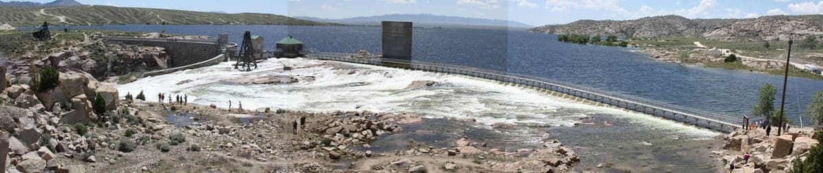
Pathfinder Dam spilling in June 2010, about 45 miles southwest of Casper. Pathfinder is the storage end of this chain: what it holds back runs down through Fremont Canyon into Alcova, Alcova swings it for hydropower, and Gray Reef smooths those swings into the steady flow you actually fish.
This is the question behind most Grey Reef searches, and the answer is a combination of four things rather than any one magic ingredient.
Temperature stability. Deep reservoir releases hold the tailwater in a narrow band year-round. Trout here do not shut down for four months the way they do on a freestone. They feed in January. Twelve months of feeding compounds into size.
A forage base built for growth. The bugs here are the high-calorie, always-available kind rather than the seasonal kind. Scuds, aquatic worms and annelids, midge larvae, leeches, and crayfish are in the drift all year, supplemented by eggs during the spring and fall spawns. Fly shops that guide the water, including Vail Valley Anglers, consistently point at that group of foods rather than at the mayfly hatches when they explain the size. That is why a red worm and a scud will outfish a matched dry on most days here, and why your nymph box matters more than your dry box.
Clean spawning gravel. The March flushing flow is the reason the population is self-sustaining. Fine sediment smothers eggs. Ten days of scouring every spring keeps the gravel functional.
Restraint on harvest. From Gray Reef Dam down to the Wyoming Highway 220 bridge, the limit is one trout per day and every trout under 20 inches must be released. Combined with the flies-and-lures-only rule, that keeps big fish in the river.
On numbers, be careful about what you read. The figure I would trust is Wyoming Game and Fish's own: over 3,500 trout per mile, cited in their 2026 flushing flow release. Outfitters commonly quote higher counts, 5,000 and up, for the top few miles below the dam. Those may well be accurate for that short reach, but I could not tie them to a published survey, so treat them as shop estimates rather than agency data. Either number describes a river with a lot of fish in it. Average size runs roughly 16 to 20 inches across the upper river, with legitimate shots at fish in the 5 to 10 pound class.
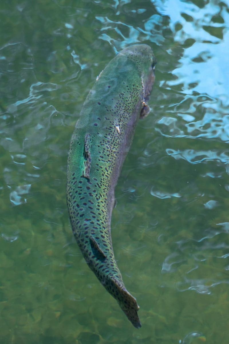
A rainbow trout. Rainbows dominate the upper Reef, where stable temperatures and a year-round food supply do the rest.
Everything above says the same thing about flies: this is a subsurface river most of the time. The dry fly fishing is real, but the reason people land big fish here is nymphs.
Carry these every month: Orange or grey Scud #14-16, San Juan Worm #10-12, Annelid Red #14, Sparkle Worm Red #10, Zebra Midge #18-22, Pine Squirrel Leech #8-10. That box alone will fish any day of the year.
Then add for the season: midge pupae #20-22 and a Griffith's Gnat #18-20 in winter; Baetis emergers, WD-40 #20, Sparkle Dun #18, and egg patterns in spring; PMD Comparadun #16, Poxyback PMD #18, Elk Hair Caddis #14-16, Yellow Sally #14-16, Trico Spinner #20-22, and August hoppers in summer; Woolly Bugger #4-8, Sculpzilla #4-6, articulated leeches, and Nuke Egg #10-12 in fall, alongside a second BWO push that is often better than the spring one.
Two North Platte originals worth having in the box: the Platte River Spider, a soft hackle swung through riffles during Baetis and midge activity, and the Platte River Special, a flashy attractor nymph that earns its keep as the lead fly in a two-nymph rig.
Grey Reef's reputation suggests more walking water than actually exists. Most of the corridor below the dam runs through private ranch land, and Wyoming trespass law is enforced along it. Wyoming law gives you the water, not the banks, so on the private stretches you can float through but you cannot anchor, beach, or wade.
Below Government Bridge there is additional public fishing at Clarkson Hill and By The Way Ranch, and the Whitetail-to-Sechrist run is the longest continuous stretch of public water on the river.
If you arrive without a boat, you have realistically three places to spend the day in the famous upper river: the access area at the dam, Trapper's Route, and Lusby. On the BLM ground below the dam, the named spots are Blue Gulch, the Redds, and Pete's Draw. Boundaries out here are signed by color: blue signs mark public water, red signs mark posted private. Learn that before you walk. That is enough for a good day at 500 CFS, especially midweek in winter or late fall. It is not enough for a three-day trip, and in July at 2,300 CFS it barely works at all. Plan accordingly: hire a guide for at least one day, or build the trip around low water.
| Stretch | Distance | Character |
|---|---|---|
| Gray Reef Dam to Lusby | ~8.4 miles | The famous water. Highest densities. A full day with fishing, roughly four hours if you row it straight. |
| Lusby to Government Bridge | ~4.5 miles | Medium-depth riffles mixed with longer slow stretches. Thin at winter base flow. |
| Government Bridge to Whitetail | ~2 miles | Rocky riffles. Fish hold shallow here and most boats row past them. |
| Whitetail to Sechrist | ~10 miles | Longest continuous public stretch. Rocky riffles throughout. |
| Bessemer Bend to Robertson Road | ~8 miles | A fall favorite as browns move up to spawn. |
Two things skew every one of those times. Flow, obviously: the same stretch takes far longer at 500 CFS than at 2,500. And wind, which can turn a downstream float into rowing uphill. Build slack into the plan.
Unlike the canyon water below Kortes Dam on the Miracle Mile, Grey Reef has no whitewater. It is a broad, smooth river with riffles, shelves, and long flats, and a competent oarsman with a drift boat or raft can run any of these stretches. What makes it hard is wind, cold water, and reading a big featureless surface well enough to put a boat where the fish are. At winter base flow some of the lower stretches get skinny enough to bump gravel. Shuttles are the practical hurdle: several Casper outfitters and Trout On Inn run vehicle shuttles between the ramps, and arranging one is cheaper than the two-car dance.
Casper sits at about 5,300 feet in open North Platte valley country. The National Weather Service climate record for Casper describes frequent southwest winds in the 25 to 40 mph range, and the monthly averages tell the same story: January is the windiest month, July and August the calmest, and even the calm months run roughly 8 to 9 mph. Averages hide the gusts. Plan for wind on every trip and treat a calm day as a gift.
What actually helps:
There are no trees. There is no shelter on the bank, no coffee shop three miles down the road, and thin to nonexistent cell service in stretches. Bring layers, water, and a windproof shell in every season including August, and do not test shoulder-season mud with a low-clearance car.
They are both on the North Platte, both tailwaters, both hold big fish, and they fish nothing alike. Pick deliberately.
| Grey Reef | Miracle Mile | |
|---|---|---|
| Character | Broad, smooth, big-water tailwater | Shorter, steeper, more structure and pocket water |
| Primary method | Float | Wade |
| Public bank access | Limited, three main areas up top | Extensive, most of it crosses public land |
| Drive from Casper | ~30 miles, paved | ~50 miles, ends on dirt that turns to mud |
| Peak season | Spring for numbers, October-November for size | Spring rainbows, November-December browns |
| Services and bailout | Casper is close, shops on the highway | None. No cell service. Come self-sufficient. |
The short version: if you have a boat or a guide day in the budget, or you want the best odds on a lot of good fish, fish Grey Reef. If you want to walk all day on your own two feet, and you are willing to drive a dirt road and be genuinely remote, fish the Mile. Full detail on that water lives in the Miracle Mile section of our North Platte guide.
If you like this kind of water generally, the Bighorn is the closest comparison in the region, and our roundup of tailwaters that fish year-round puts Grey Reef in context.
Wyoming rewrote several rules for this stretch effective January 1, 2026, and they are enforced. Verify against Wyoming Game and Fish and the Area 5 regulations before you fish, because this page is a summary and the agency is the authority.
Hooks. Single-point barbless hooks are required on Gray Reef, and also on the Miracle Mile, Alcova Afterbay, and Fremont Canyon. The change came out of hooking-injury data on heavily fished catch-and-release water.
Tackle. Artificial flies and lures only on Gray Reef. As of 2026 that zone extends downstream to Government Bridge, further than it used to.
Pegged attractors are prohibited at Gray Reef and Fremont Canyon. Free-sliding beads and soft beads remain legal. If you fish beads, learn the distinction before you rig up.
Creel. From Gray Reef Dam downstream to the Wyoming Highway 220 bridge: one trout per day or in possession, and every trout under 20 inches must be released. The regulations call that downstream boundary the Highway 220 bridge and the 2026 announcement calls it Government Bridge. It is the same crossing, about 22 miles southwest of Casper.
Spawning closures, April 1 through May 15. Two separate reaches close to fishing:
Both are signed and patrolled, and fishing them carries real penalties. Rainbows spawn well outside those boundaries too. Watch for clean, pale gravel with fish stacked over it and walk around it. Our fall spawn and redd guide covers what a redd looks like and why stepping through one matters.
Guides. Wyoming now requires commercially guided fishing vessels to register annually for a $325 fee and display the registration while operating. If you are booking, your outfitter handles it, but it is a reasonable thing to ask about.
Platte River Fly Shop (Casper): operating since 1994 and the longest-running Grey Reef outfitter in the area. 7400 State Highway 220, on the way to the water.
The Reef Fly Shop / North Platte Lodge: the first permitted outfitter on the Reef, on the river with lodging on site. They have stopped selling fishing licenses, so buy yours before you arrive.
Ugly Bug Fly Shop / Crazy Rainbow (Casper): guides on both the Reef and the Mile, and the most consistently updated conditions reporting in town.
Grey Reef Anglers: StealthCraft float trips covering 8 to 16 river miles in a fishing day. Half day $550 per boat, full day $675 per boat, one or two anglers. 307-267-2559.
Four Seasons Anglers: guides the Reef, the Mile, and the upper North Platte, with detailed hatch information on their site.
Trout On Inn: lodging essentially on the river at Lusby, with drift boat rentals and shuttle service. 307-462-1917.
Casper is the base: full services, an airport (CPR), and a 30-to-40-minute drive to the water. Denver is about four and a half hours south, which makes Grey Reef a plausible long weekend from the Front Range. Book spring and fall guide days months out. If you are building a wider Wyoming trip, Pinedale and Jackson Hole are the other anchors, both a long way west.
Roughly 500 to 1,500 CFS is the range most anglers prefer. Winter base flow sits near 500 CFS and gives the best wading of the year. Summer irrigation releases push the river to 2,000-3,000 CFS, which is float water for almost everyone. Grey Reef is a managed tailwater, so flows change on the Bureau of Reclamation's schedule rather than with the weather.
Yes, but the options are limited and most of the corridor is private. Public wading is concentrated at the Gray Reef Access Area below the dam, Trapper's Route, and the Lusby Public Access Area, which holds about 2.1 miles of river. Everything in between is private bank. A drift boat reaches far more water, which is why Grey Reef is a float fishery first.
Stable tailwater temperatures, year-round flows, and a forage base heavy in scuds, aquatic worms, midge larvae, and leeches let fish feed hard twelve months a year. Annual March flushing flows have kept spawning gravel clean since 1995. Wyoming Game and Fish reports the trout population now averages over 3,500 per mile, up from under 400 before the flushing program started.
Both. The dam and reservoir are officially Gray Reef, which is the spelling the Bureau of Reclamation and Wyoming's fishing regulations use. Anglers, fly shops, and outfitters almost always write Grey Reef. They refer to the same tailwater below the dam southwest of Casper.
March. It runs ten days, with flows cycling from about 500 CFS up to 4,000 CFS in the pre-dawn hours and back down by 10am. The exact dates shift year to year. In 2026 it ran March 5 through 14, roughly two weeks earlier than normal because of maintenance at the dam.
Every bug and forage item this river feeds, laid out by month. Filter by category or hook size, or flip the axis to see what comes off at what hour of the day. Drawn from our western hatch and forage guide.
On a freestone, a flow reading tells you whether it rained upstream. Here it tells you which phase of the release calendar you are walking into:
Live Grey Reef flows on RiverReports plot today's reading against the same date in past years, which is how you tell an ordinary year from an operations surprise.
Weekly flow updates and fishing intel.
© 2026 RiverReports, Inc.